Showing posts with label serre-poncon. Show all posts

Sunday, 26 August 2012

Crête de La Gardette

A serene alpine pasture walk to a mountain pass and a hill with tremendous views.


TOTAL DISTANCE: 10.2km
APPROXIMATE TIME: 2hr 30mins

START: Les Gournieis
FINISH: Les Gournieis

This walk sees the return of the hamlet of les Gourniers, though rather than a valley walk the Col de la Gardette is a mountain pass at the end of a pleasant - though in places steep - walk up hillside and through meadow. Navigation can be tricky in places, but the views at the top are tremendous.

Saturday, 25 August 2012

Pic de Chabriere (another alternative route)

The last of three route suggestions atop everybody's favourite alpine peak...


DISTANCE TO THE TOP: 9km
APPROXIMATE TIME TO THE TOP: 2hrs

START: Lac de Saint Apollinaire
FINISH: Lac de Saint Apollinaire

In two previous posts, I have suggested routes onto the Pic de Chabriere via the ridge to the south east of the peak, namely the Serre de Mouton. This walk offers a new route which does not ascend via this ridge and offers a pleasant alternative. 

Thursday, 23 August 2012

Mont Guillaume

A varied route through forest, across alpine meadow and up mountainside with great views of Lac de Serre-Poncon, the Queyras and more. A perfect day's walk.


TOTAL DISTANCE: 9km
APPROXIMATE TIME: 3hrs 30mins

START: Foret Communale d'Embrun
FINISH: Foret Communale d'Embrun

Mont Guillaume lies to the west of Embrun; you cannot help but notice its forested flanks from the town. These flanks play host to many routes and objectives. Indeed, many tourists and young families come to Mont Guillaume not to climb the peak itself, but to see the Chapelle de Seyeres, which is approximately half way on this walk. For the more intrepid explorer, however, the rewards for ascending Mont Guillaume are fantastic views, as well as a couple of surprises on the way too. 

The view of Lac de Serre-Poncon from Mont Guillaume's summit

The walk begins at the car park at the entrance to the Foret Communale d'Embrun. This is a beautiful woodland, in which the sunlight forms in dapples beneath the evergreen trees. Take the path indicated by the sign "La Chapelle de Guillaume", which is a slanting little path up the  hillside and through a gate in the electric fence. Continue to follow this path up through the forest - passing a small fenced-off plantation on your left - until you hit a larger track with signposts pointing in either direction.

This walk is signposted brilliantly - I haven't seen signposting as good as this since walking in the Pyrenees. Follow the track round to the left, until you come to another junction and another signpost. Of the three different routes, choose the one going round to the left (the one with the 'no vehicles' sign). Follow this round the contour of the hillside, and before long you'll be aware of the cattle which inhabit the Foret Communale, either by the sound of the cowbells echoing between the pines or because of the presence of droppings on the ground.

Soon you will stumble upon the signpost indicating the border between the Foret Communale d'Embrun and the Foret Dominale de Mont Guillaume. There appears to be a slight difference between the two: the Forest Dominale appears to be less ordered and has more deciduous woodland, though this may purely be because the terrain is somewhat steeper here on in. Look out for cattle in this area too. Continue along this wide track and you soon come to a junction, with one path leading down the hill, one leading up the hill, and the main track continuing along the contour. Take the path going up the hillside.

This path goes around the perimeter of the hillside, then doubles back on itself higher up. There is a drop on the left (and, later, the right) but the path is wide and safe enough for you to not even notice it. At the next signpost, turn left and carry along the side of the hillside. Then, at the head of this path, do as the signpost indicates and turn left.

Almost immediately after this junction, you begin momentarily to leave the woodland, entering a beautiful glade flooded with sunlight. Through the remaining trees you catch a glimpse of the view you will ultimately be gifted with, whilst picnic benches offer a great mid-point rest; there is even a water fountain for you to fill up your water bottles. The centrepiece of the glade takes the form of the Chapelle de Seyeres, a small catholic chapel whose location is only bettered by the Chapelle de Mont Guillaume, found on the very summit of the mountain itself.

The view from Mont Guillaume along the remaining ridge. The Aiguilles de Chabrieres can be seen to the south

Continue through the glade, returning into the trees (though they are more sparse). At the next signpost, turn right up the hillside. Continue up through the remainder of the forest until the trees clear and you find yourself in a spectacular mountain corrie, with the crags ahead forming the wall of the alpine basin. The surrounding wild meadow is also perfect marmot territory, so look out for them.

The next section of the walk takes the form of long, snaking lassettes. These zigzag paths make the climb more gradual, and offer a longer amount of time to admire the beautiful basin.

Soon, as you traverse the contour of the hill , you will see a wooden cross on a mound ahead of you. You do not visit this cross (though you will visit another cross, namely the one found on the summit itself), though it makes for a good reference point. Just after first glimpsing this cross, you will come to a junction. There are two choices here which both lead to the top: a continuation of the zigzagging route on the lower path, which is a more gradual climb but longer; the higher path (indicated by the cairns) is a steeper, shorter climb up onto the hill. Take the latter. 

Follow this higher track upwards then, and you will soon come to another junction. This time take the lower path; the other is an unnecessary shortcut which is steep and slippery.

Follow this path round and, soon, you will be able to see the wooden cross on the top of Mont Guillaume - not far to go. For a small section on this path you will walk through a small patch of wildflowers; the yellows, purples and reds add colour to the many greens and browns of the view.

This view is amazing: the entire eastern skyline is full to the brim with mountains. The points of the Queyras regional park dominate the northern part of this view, with the green mountains overlooking the Vars and Ubaye valleys completing the arc of montagne which concludes with the Pic de Dormilouse in the south. The juggernauts of Monte Viso and the Brec de Chamberons are two particular points of interest, not only because of their size but also due to their marking of the French-Italian border.


Continue the last few metres to the top. The wooden cross, now as symbolic to the humble walker as it was to the hundreds of Christian pilgrims, and the Chapelle de Mont Guillaume are there to greet you. To the south you can see the Lac de Serre-Poncon and the points of the Aigilles de Chabriere; to the west the hills on the periphery of the Ecrins national park block the wonders beyond, with the one exception of Mourefroid, which looms to the left of the trio of western peaks.

This is a lovely walk and, after spending a good while on the top, retrace your steps to see it all over again. This is a fantastic walk with fantastic views.

Wednesday, 22 August 2012

Pic de Chabrières via the Serre de Mouton (alternative route)

Fancy an alternative route to the Pic de Chabrieres? Here's one...


TOTAL DISTANCE: 10.4km
APPROXIMATE TIME: 2hrs 30mins

START: Lac de Saint Apollinaire
FINISH: Lac de Saint Apollinaire


There are so many routes from the Lac de Saint-Apollinaire that it seems a waste not to show you the full array. This alternative route onto the Pic de Chabrieres, with the craggy Aiguilles beyond, goes some way to rectifying that. 

Begin once again at Lac de Saint Apollinaire, and again head up the steep dusty path found to the right hand side of the 'lake', indicated by the white and red horizontal signs. Continue up this track until you reach the wide, contour-traversing track which we briefly crossed over on day one.


View this route on a Larger Map

Once you reach this track, follow it round to the right, along the eastern edge of the hill. This is a nice, gentle walk through the pine forest, though open enough to see views of the northern mountains which border the Ecrins national park. In warm, sunny weather also look out for lizards, as they enjoy the dry ground that the forest floor offers.

Continue along the path and you will come to a small glade with log benches; this is an ideal resting point if you're still recovering from the initial slog up the hillside!

As you may have noticed, the track you are now following is indicated by orange and blue circles. This is important, as soon the route up onto the Serre de Mouton ("ridge of sheep"; see the Pic de Chabrieres route) leaves this track soon. Be sure to take the path up the hillside indicated by these circles.

Following this smaller, steeper path up the hillside you will soon come to a plateau and a messy junction of paths. Be sure not to ascend the hillside too early; wait until you have found the signpost (the one with the figure of the walker) which reveals the correct path.

Continue to ascend through the forest and the extent of the trees will begin to dissipate. When you come to the sign on the tree which shows an arrow downwards and an arrow to the right, go slightly beyond this tree and take the path up to the right.


The Pic de Chabrieres on the left, with the Aiguilles de Chabrieres behind it to the right

Soon you will be in familiar territory, as you will find yourself on the same open route I have previously suggested. Indeed, from here you can choose to ascend to the pinnacle of the Serre de Mouton or go further and onto the Pic de Chabrieres. I suggest using the route previously suggested as a quicker descent, offering if nothing else a circular route. Considering the lack of scope for such routes in the Alps, plus the lovely forest walking this offers, make sure not to miss out on this lovely walk.

Monday, 20 August 2012

La Viste

A unique little walk overlooking the Lac de Serre-Poncon


TOTAL DISTANCE: 6km
APPROXIMATE TIME: 2hrs 30mins

START: Rousset
FINISH: Rousset

After walking in a certain area for a good length of time, you can begin to create vague categories of routes and walks. For instance, in this area you can begin to discriminate between the valley walks of the Ecrins and the mountain walking of the Queyras. La Viste, however, which sits outside both the Ecrins and the Queyras parks, is equally outside any form of categorisation. It lies to the south-west of the Lac de Serre-Poncon's barrage and is a steep wooded hike.

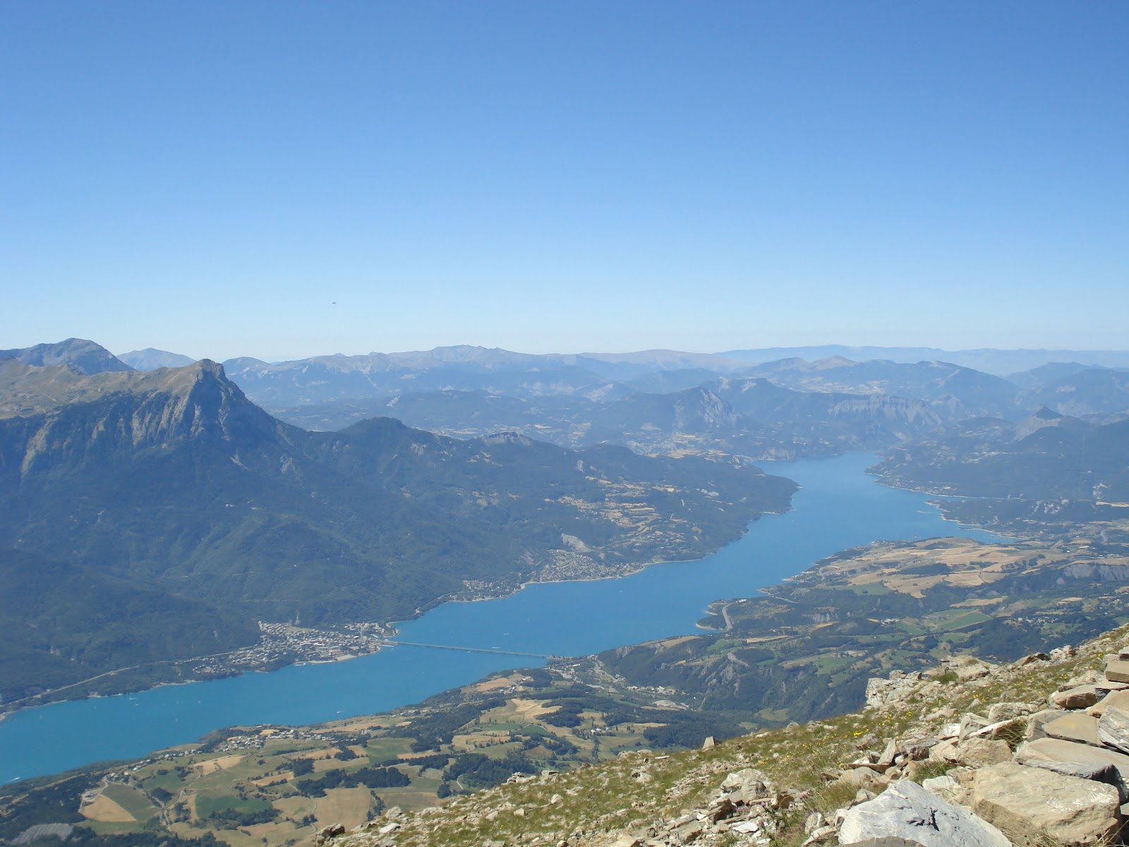
The view from La Viste. The blue pool is the tip of the Lac de Serre-Poncon

Park wherever you can in the small hamlet of Rousset up the hill from the barrage (which is, incidentally, the largest dam in Europe and a great place to buy souvenirs). Although there are few designated parking spaces, there is more than enough space to park on the eastern periphery of the small village.

From here, head to the centre of the hamlet, where hopefully you will spot a yellow and red horizontally-striped sign. Follow these signs for this walk.

The walk begins along a dusty track through an arrangement of yellow fields; depending on the time of year you may be met by either fields of barley or large hay bails, which are scattered around in many of the fields. Patches of woodland appear occasionally to both the left and right.

At the junction approximately a hundred metres from Rousset, take the higher track.

As the incline of the track begins to increase, you will begin to see the recognisable point of la Viste in front of you, the strange smattering of trees along its southern face and the slag-grey tinge of its lower crags just two of the mountain's quirks.

As the track veers to the left, and the base of la Viste forms the walker's handrail on the right hand side of the track, the land on the left of the track falls away and the views of the hidden valley beyond begin to open up.

This valley is spectacular: the road on its western edge and agricultural areas cling to the side of the cliff opposite; the hamlet of Viere nestles at the edge of the gorge surrounded by high hilltops.

Continue down the track, and an altogether different sight appears: a hillside full of solar panels offers a different view altogether, and a reminder of the changing nature of these mountain areas, especially those outside the boundaries and sanctuary of the national and regional parks.

However, though the view into the valley is a unique one, careful attention must be payed to the right hand side of the track, as you need to spot the path up onto the hillside itself.

During your journey along this track there should be three paths up to the pinacle of la Viste: the first is a signposted path, which is steep and takes you up too early; the second is not signposted and not on the map so should be ignored; the third is the path to take.

This is itself a steep path, but if you persevere up through the woodland for approximately four hundred metres, the incline will begin to plateau and you can begin to see between the trees to the views beyond.

The views here are indeed tremendous: the full ridge is displayed to the south, whilst the lac de Serre-Poncon and the mountains beyond reveal themselves through the trees.


Care must be taken, however, as the path from here on falls away in places; viewspotting here should be taken with the greatest amount of care, and any perseverance towards the very top itself is not advised due to the dangerousness of the cliffs and the unreliable nature of the path which hovers very close to them.

As the incline begins to level out, suddenly the land falls away.

Instead, I advise to remain at the first level section and admire the views from here. Afterwards, retrace your steps back to Rousset.

A lovely morning or afternoon walk with unique views, la Viste is a very different walk to others in the area.

Saturday, 18 August 2012

Pic de Chabrières via the Serre de Mouton

A steep climb through woodland and ski resort-style open hillside, with great views to the south and east. 


TOTAL DISTANCE: 8.4km
APPROXIMATE TIME: 2hr 15mins

START: Lac de Saint Apollinaire
FINISH: Lac de Saint Apollinaire

If you are anywhere near the Lac de Serre-Poncon, you cannot help but notice the jagged points above its western edge. These are the Aiguilles de Chabrières, which sit proudly above the small village of Saint Apollinaire and its eponymous lac. This walk, whilst not taking you onto the craggy Aiguilles themselves, leads you onto the point in front of it, known as the Pic de 
Chabrières. 

The Aiguilles de Chabrieres


The walk begins at the Lac de Saint Apollinaire. While calling it a lake is a slight exaggeration, this sheet of water is no doubt beautiful, and from here alone you have fantastic views of Pic de Morgon and the Queyras mountains.  I suggest parking outside the Campéole campsite, as there is usually a lot of space here, and then walking to the right hand side of the pond, heading towards the steep uphill track indicated by the white and red sign (see "Notes on signposting").


View this post's route on a Larger Map

From here, ascend up the path; this should take between 20 and 30 minutes, though due to the steep contours, perhaps allow for a little longer. The path snakes up through the pine forest; in summertime the paths are littered with pine-cones. 

At the top of this steep path you will hit a wider forest track which follows the contour of the hill. While in a couple of later posts we will be following this track round to the right, on this occasion follow  the track round to the left until, around the corner, appears another equally wide tributary track heading diagonally up the hillside. 

After following this track you will come to a small plateau or platform, on top of which nests a rather ramshackle hut or shelter. There is also a small water trough here; it should be fine to drink from though if there isn't a sign saying "l'eau portable" its probably best just to leave it alone! Take the signposted track to the left of this shack.

The following path through the remainder of the pine forest takes the form of lassettes, which is French for laces, basically meaning zigzags .


The nature of the path here therefore means that an otherwise steep trek up through the pine trees becomes a gentle walk, with the forest often giving way to open, sunny glades with yellow grass, wild flowers and a rainbow of butterflies making the ascent an ever-changing and interesting one.

This is without even mentioning the view, which appears occasionally as the tree cover decreases. Lac de Serre-Ponçon is ever-present, the deep blues contrasting with the greens and browns of the mountains above it.

The view gets even better once the forest is completely behind, and open, grassy fell side is all that is left until the top.

The ascent here becomes somewhat steeper without the lassettes of the forest to make the incline gentler, and on a hot day this ascent can prove quite tough indeed. However, this is of coursed counterweighted by the improving view, with Mont Guillaume and the start of the Provençal hills appearing to the north and south respectively.


Mont Guillaume from the seating area at the top of the Pic de Chabrieres

After a short climb, a peak of sorts is reached; the path intersects two small knolls. This is the summit of the Serre de Mounton (meaning "edge of sheep", which is strange because there doesn't appear to be any sheep for miles!) These two little hills have fantastic views: the southern knoll in particular has great views of the lac and the mountains towards the Mercantour  national park and the Italian border.

From here, a brief descent is followed by the final ascent of the day, the path veering off to the left at the bottom of the dip and towards the cliffs' edges along the mountain's southern edge. As a result, a different route is recommended, with the wide, flat track to the right followed by the steep ascent up the ski slope before joining the track at the top suggested.


This area between the Serre de Mouton and the Pic de Chabrières is also a great place to find marmots. For those of you who don't know, a marmot is a small beaver-like animal which is native to much of the Alps and the Pyrenees. They live in burrows and tend to reside in large alpine pastures or other high, upland areas. Indeed, in this small area between these two hilltops, we saw at least five different marmots. You have to know what you're looking for, though: many people walk a tremendous amount in the Alps but hardly ever see a marmot at all. 

An elusive marmot hides among the shrubs.
   Back to the walk. At the top of the last ascent, you will see a small hut used for skier's chairlifts. Ignore this, and instead follow the track up to two fenced areas: the first of these is a seating area (pictured above); the second is an observation table. This is the pinnacle of the Pic de Chabrières. On a clear day you can see Mont Seoline to the east (beyond Mont Morgon) and towards the Queyras regional park to the north east, with the flat-topped gable-like Brec de Chamberons indicating the Italian border. To the south, you may even be able to see Mont Ventoux in Provence. This whale-backed mountain, as the observation table confirms, is over 90km away.

Me in front of the Pic de Chabrieres, with the Aiguilles 

You can ascend onto the crags of the 
Aiguilles de Chabrières, though experience (and climbing gear) is recommended. Instead, either descend the way you came up (this is particularly enjoyable as the view remains in front of you) or use one of the routes I will describe in future posts as your descent. 

As mentioned, we will be returning to this mountain later on. Nonetheless, this route offers a beautiful and varied - yet quiet - walk with fantastic views and a great starter to any Alpine holiday.

Search This Blog