The town of Luchon is one of the most visited in this part of the Pyrenees, and it is quite easy to see why. Not only is its location picturesque and very close to some of the attractions I have already highlighted in the blog so far - such as the St. Bertrand de Comminges and Lac d'Oô - it also has some unique qualities of its own.
One of the major attractions is its large spa baths, housed in fantastically ornate buildings which act as great monuments in themselves even if you aren't a spa frequenter. More widely, Luchon is a haven for cafes and souvenir shops, and I would heavily suggest you take the time to enjoy both.
Showing posts with label 2014. Show all posts
Showing posts with label 2014. Show all posts
Saturday, 20 September 2014

Tuesday, 16 September 2014
Lac d'Espingo (via Lac d'Oô)

DISTANCE: 12.2km
APPROX TIME: 3 hours
START: Les Granges d'Astau
FINISH: Les Granges d'Astau
We are coming very close to the end of the series of blog posts covering my latest venture to the Pyrenees, and it is at this point I can look back and remember how much I've done already. Perfect picture-postcard valley walks, views from the highest mountain passes the Pyrenees has to offer, and of course the dizzying heights of the Pic du Midi are just some of the sights we've uncovered over the past few days and posts. Is it possible, I hear you ask, for any other walk to better what has already come before? This walk, up past the awe-inspiring Lac d'Oo to the cloistered Lac d'Espingo, might just do that.
This walk begins at the peculiar little settlement of Les Granges d'Astau, which appears to comprise of purely two or three houses... and a considerably-sized restaurant. By road, the hamlet is slightly up the valley from the town of Oô, where the lake gets its name.
From the car park at Les Granges d'Astau, follow the path southwards. This begins as a gentle walk through a grassy Pyrenean plain, where cattle and horses graze on the land. From here, the track begins to incline into long swooping lassettes (zigzags). What strikes you about this section of the walk is the sheer amount of water - little streams and rivers continually invade the path, with rills dug into the path to aid their passage down the hillside. This volume of water means there all sorts of plants growing either side of the path, and it almost feels jungle-like as you continue the long ascent into and through the forest beyond.
Soon the track begins to level along the contour of the hillside, before falling slightly and rising again, coming out of the forest and into the valley beyond. At this point the view is already tantalising: rocky mountain scenery foregrounded by rolling hillocks; the dam (always an exciting sight for what may lay beyond) sitting straight ahead, with a refuge sat the other side of the shallow river which flows down to your right. Slightly up the path there is a bridge which takes you over the river to the refuge, but instead carry on along the left side of the river, next to the high cliffs on your left, to see what lies beyond the dam...
 |
| Lac d'Oô |
However a beautiful place to sit and stare, Lac d'Oô is not our destination, so follow the path to the left, around the eastern side of the lake. You will soon re-enter the woodland, with the footpath zigzagging up the hillside through the forest. The path then levels onto a terrace, and you will soon come out of the woodland to be greeted by great views of the lake, the main waterfall and its smaller neighbours which fall from the hills surrounding the lake's western edge.
As you walk along the terrace, you will come across two waterfalls which need to be traversing. These are stunning up close, with water pouring onto the track. It can be slippery here (and on a sunny day there is nothing worse than getting your feet wet on a walk!) so be careful with your footing when crossing these two.
 |
| Up close with one of the waterfalls. |
 |
| Wildflowers |
 |
| This way! |
 |
| The Lac d'Espingo, the mountains and the refuge. |
Saturday, 13 September 2014
Plo del Naou

DISTANCE: 10km
APPROX TIME: 2 hours 15 minutes
START: Col d'Aspin
FINISH: Col d'Aspin
I have fond memories of the Col d'Aspin. As a child I travelled here with my parents (from Foix en route to Luz St. Sauveur) and we stopped off at the pass to take a few photographs. Returning to the car, we found it surrounded by cattle - trying to get them out of the way to get in the car, and then trying to get them away so we could reverse and get away was certainly a memory which sticks in the brain. Returning years later, the cows are still here, and remain perhaps the biggest novelty of the mountain pass which joins the eastern and the western Pyrenees. This walk is partly an excuse to come back to the Col d'Aspin, and partly a way of gaining some great views fairly easily.
For this walk, begin at the Col d'Aspin, trying your best to avoid all of the cattle which appear to love to congregate around the carparking area (don't worry - they're docile, just everywhere!). From here, take the path heading westward into the forest. The path is steep at first, but then the incline becomes more gradual. The forest either side is dense, but the track is very clear and solid underfoot.
 |
| The Col d'Aspin, including cows. |
From here, walk up the path towards the top, then veer off through the wood onto another track. Walk along this path, which follows the contour of the hill. The benefits of walking this path are the great views north, including the Lac de Payolle below you and, if you're lucky with the weather, Pic du Midi. The terrain of this hillside is quite unique in this area, with a great abundance of heather covering the area either side of the path.
Continue along the contour of the hill round until the Plo del Naou (the destination of this walk) is directly between you and the Col d'Aspin. While the cattle seem to love the Col d'Aspin, this little pass seems to be the grazing area of choice for lots of sheep. Much more spectacularly, this area is also a great place to see birds of prey, including eagles and griffon vultures. When I walked this recently, I was fortunate enough to see three of the latter set off from the hillside here and swoop down into the valley towards the Lac de Payolle - another fantastic moment you can find on this walk.
 |
| The view northwards, with the Lac de Payolle in the bottom left. |
The top itself is marked by a small cairn with a yellow cross on the top. At this point you should be careful as there is a steep drop on the southern side of the hill.
 |
| The Plo del Naou. |
The Col d'Aspin is one of the places you have to go to in this area. Like the Col du Tourmalet it is perhaps better known by cyclists, but like its more famous counterpart it also offers great views for very little effort. This walk to the Plo del Naou is arguably purposeless as a result - it basically provides a walk from the Col d'Aspin, as opposed to a walk to a particular destination. However, if you do take this hike west of the Col, you're treated with some hidden moments, like spotting the Lac de Payolle or watching the vultures. A great walk from an eventful mountain pass.
Monday, 8 September 2014
Refuge de la Soula, via Gorges de Clarabide

DISTANCE: 11km
APPROX TIME: 3 hours
START: Pont du Prat
FINISH: Pont du Prat
This walk to the Refuge de la Soula is one of those walks. Located at the head of the Val Louron - and therefore, along with the previously two Cols which sit either side, one of the definitive walks of this valley - seems on paper like a relatively gentle walk. It will make for a nice Pyrenean valley walk, we thought, but wouldn't be as spectacular as others in the area. We were wrong.
While you can walk it from anywhere in the valley if you want to, I would suggest starting from the Pont du Prat: the bridge at the very head of the valley, next to the hydroelectric station. Because it is outside the national park, hydroelectricity is a prominent feature of this valley, and you will find many aspects of it on this walk as well.
Walk from the bridge and round the right of the hydroelectric station, and you will see a footpath - take it as it enters into the forest ahead of you. From there, you will soon come to a fork in the path - take the right-hand path.
One of the curious things about this walk is the range of information boards placed along the path as you ascend - some tell you about local wildlife, while others inform you about the flora growing in the valley. If your French isn't too shabby they are well worth a read, and a quirky addition to this walk. The first of these is just after the aforementioned fork in the path.
After this, the path takes the form of a series of zigags through the forest. Follow these until you hit another fork in the path.
This fork is quite an important one: our path carries on ahead, up the hillside. The other path, however, takes you down a different valley, the Vallee de la Pez, and is also no doubt a great walk. However, for today continue up through the forest.
The path here once again takes the form of a series of zigzags, but this time they are much longer lassettes, which loop back and forth as you climb higher up the wooded hillside. On your route look out for any further information boards. On your journey up the mountain you will also repeatedly cross the main hydroelectric pipeline; it feels a little strange using wooden bridges to cross water when it's in a pipe, but acts as a constant reminder of the value the mountains and waterways play to the local area far beyond their aesthetic beauty.
Soon you will emerge from the forest, and onto an open craggy outcrop. The path curves back on itself and up the rock face, before levelling off again. It is then that it becomes apparent this is no ordinary valley walk.
 |
| The Gorges de Clarabide |
Look around, and you will see that you are on one side of a gorge: the Gorges de Clarabide, to be precise. Hundreds of feet below you a river hurtles through the bottom of the valley, with a sheer cliff face separating you from that drop. It's a relatively dangerous prospect, but one you cannot help but love: the high, sloping mountains on either side and the forests which drape over their lower reaches makes for a view which is full of Pyrenean splendour. It may well be for this reason alone that you traverse the path round the perimeter of the gorge, but I highly recommend you do.
The path is relatively narrow so take care, but if you stay into the side you should be fine. There are also chains fixed into the cliff wall next to you to act as easy handrails. Follow the gorge round and watch as the views on the other side of the gorge open up, and the head of the valley gets ever closer.
When you reach the head of the valley, it is almost as you expect: you come into a high, Pyrenean pasture, with lush green meadows and high craggy walls; the sort of place you long to be when visiting a high upland area. What makes this valley different is the gorge which you have just left: to your left the river drops suddenly down into the gorge below, and the waterfall this creates is spectacular.
You start up slightly higher than the rest of the valley: head down the hill to meet the bridge which straddles the river, cross it and continue up through the valley.
Within a short walk of the bridge stands your destination: the Refuge de la Soula. Unlike many refuges in the Pyrenees, the Refuge de la Soula appears large, spacious and relatively modern. This perhaps again reflects the importance of the hydroelectric works to this valley: the hydroelectric station sits next door to the refuge.
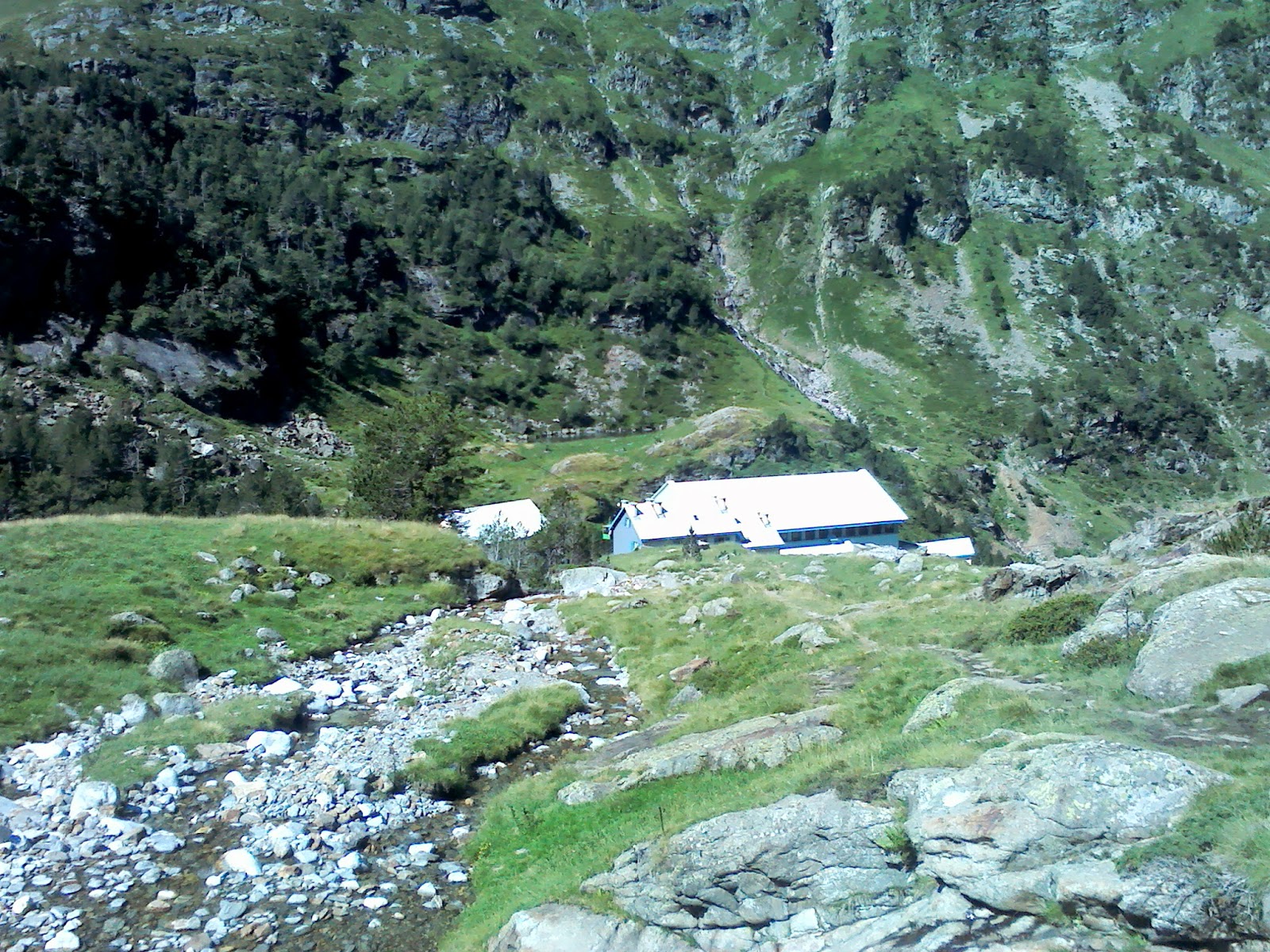 |
| Looking down on the refuge from our hidden spot. |
While an important benefit to the surrounding area, some would argue that the hydroelectric station and the larger refuges make for bigger eyesores - for those people I have a fantastic little hidden gem.
 |
| Views of the valley. |
 |
| Our hidden spot on the river. |
Sometimes walks surprise you. Hiking up to the Refuge de la Soula, I thought it might be a standard valley walk. Little did I know that not only would I be walking high up on the side of a gorge as part of that walk, but also that my "destination" was not in fact the refuge, but a little hidden spot on the river I had been following for the whole time. This is one of the best examples of what the Val Louron is all about, and well worth a visit.
Friday, 5 September 2014
Pic du Midi de Bigorre

DISTANCE: 13.2km
APPROX TIME: 3 hours 15 mins
START: Col de Tourmalet
FINISH: Col de Tourmalet
At 2,877 metres, and set back to the north of much of the Pyrenees, the Pic du Midi towers above its neighbours in a way which allows you to see for miles and miles. On many days, you can find yourself standing at the top of the Pic du Midi and be above the clouds. If this is not remarkable in itself, the fact that there is such an easy walk to the peak's summit is. While you would normally have to get your crampons and ropes out to gain the height and vast views such as these, yet the hike up to the Pic du Midi's summit is very straightforward. What is even more remarkable than that, however, is that in 1878, someone decided to build an astronomical observatory on that very summit. This is a place which boggles the mind, a height which tightens the lungs and a climb which gets the heart pumping. Are you ready for it?
You begin at the Col de Tourmalet, itself perhaps the most iconic Pyrenean mountain pass for its position as a centrepiece fixture in the Tour de France. For this reason, the pass tends to be very busy - indeed, if it weren't for the sheer breathtaking awe of this walk I may not have recommended it; this walk is not exactly "undiscovered" by any stretch of the imagination. On the day I was there this year, the pass was not only busy with people but also with llamas - llamas! - who were skittishly darting about trying to avoid the traffic. Already it seems like we're in a different world, and the walk hasn't even begun!
Much of this walk will be spent on the long dirt road which leaves the Col on its north western side - follow this as it contours around the west side of the adjacent hillside. Even now, as you snake into the mountain and then back out onto a prominent spur, you begin to see the views westwards opening up.
The walk along this track continues for another half an hour or so, and in that time it will veer in and out of the hillside, with a series of tunnels punctuating the long road. Thankfully, the fact that the views westwards increase and improve with every step prevent this long stretch from ever becoming monotonous.
After this stretch, you turn a corner round the crest of the last jutting spur and there it is: the shining white citadel of the Pic du Midi observatory sits atop the peak ahead of you. Take your eyes away from it and you will noticed down to your left a lake - this is the Lac d'Oncet, a popular attraction in summer only beaten by the Pic du Midi itself. And you can see why - the picture-perfect lake sits in a glacial basin, with great banks of snow skirting its northern and western edges. Follow the track above the lake until you come to the ruined buildings of the Col de Sencours, a great place to take a break before the ascent.
Now the real work begins. The ruins are on quite a level plateau, but on the northern side the track begins to rise. Take this path, and follow it up as it takes long loops up the side of the mountain. Again, the views prevent the walk from becoming monotonous, as do the little details: at points on this stretch you enter miniature gorges where the rock was blasted away to make way for the track; big slabs now sit imposingly on either side as you ascend, and it adds to the bizarre quality of this walk. These long zigzags continue for another three kilometres, and then you will come to the next level section of this adventure, before the final push.
This next checkpoint on your walk is the site of an abandoned hostel. The building was once the signature building on the peak, but was slowly put out of business as the observatory expanded. It gives you a great view of the observatory itself though, and the last time I was up there there were walls of snow which lined the western hillside around the hotel. Once you've taken in the views, follow the path northwards to embark on the final ascent.
But wait! The path begins to the north of the hotel, and then swoops east as it ascends, but as it does so the hills to the north part momentarily to give you a view northwards. And what a view. There are no mountains northwards - the Pic du Midi is on the northern extent of this part of the Pyrenees, which is unimaginable given its size - but just the rest of France sprawling away. On a beautiful blue sky day, however, you will find yourself above an inversion. While you bask in the sunshine, the rest of France - the rest of the world - appears to be swamped in a sea of cloud, and it looks magical.
And then comes the ascent. This final section is by far the steepest and the path is somewhat eroded, so take care. The path winds its way up the mountainside in a series of sharp zigzags, and only gets harder the closer you get to the top. But the glimmering white obelisk shines bright above you, and all around you are either mountains or clouds. Your heart may be pounding, your lungs tensing, your legs aching and your head thumping, but as the air grows thinner and the summit gets closer, this is one of those scarce walks where you genuinely feel like you are on top of the world. And the observatory, like Mount Olympus alchemised with the Starship Enterprise, as to this otherworldly experience.
As you near the top, you have to crawl under a pipe, and then there is just a short walk before you reach the summit. Get onto the observation deck and have a look at the world at your feet. I would describe the view, but it is perhaps better you see for yourself:


Much of this walk will be spent on the long dirt road which leaves the Col on its north western side - follow this as it contours around the west side of the adjacent hillside. Even now, as you snake into the mountain and then back out onto a prominent spur, you begin to see the views westwards opening up.
The walk along this track continues for another half an hour or so, and in that time it will veer in and out of the hillside, with a series of tunnels punctuating the long road. Thankfully, the fact that the views westwards increase and improve with every step prevent this long stretch from ever becoming monotonous.
After this stretch, you turn a corner round the crest of the last jutting spur and there it is: the shining white citadel of the Pic du Midi observatory sits atop the peak ahead of you. Take your eyes away from it and you will noticed down to your left a lake - this is the Lac d'Oncet, a popular attraction in summer only beaten by the Pic du Midi itself. And you can see why - the picture-perfect lake sits in a glacial basin, with great banks of snow skirting its northern and western edges. Follow the track above the lake until you come to the ruined buildings of the Col de Sencours, a great place to take a break before the ascent.
Now the real work begins. The ruins are on quite a level plateau, but on the northern side the track begins to rise. Take this path, and follow it up as it takes long loops up the side of the mountain. Again, the views prevent the walk from becoming monotonous, as do the little details: at points on this stretch you enter miniature gorges where the rock was blasted away to make way for the track; big slabs now sit imposingly on either side as you ascend, and it adds to the bizarre quality of this walk. These long zigzags continue for another three kilometres, and then you will come to the next level section of this adventure, before the final push.
This next checkpoint on your walk is the site of an abandoned hostel. The building was once the signature building on the peak, but was slowly put out of business as the observatory expanded. It gives you a great view of the observatory itself though, and the last time I was up there there were walls of snow which lined the western hillside around the hotel. Once you've taken in the views, follow the path northwards to embark on the final ascent.
But wait! The path begins to the north of the hotel, and then swoops east as it ascends, but as it does so the hills to the north part momentarily to give you a view northwards. And what a view. There are no mountains northwards - the Pic du Midi is on the northern extent of this part of the Pyrenees, which is unimaginable given its size - but just the rest of France sprawling away. On a beautiful blue sky day, however, you will find yourself above an inversion. While you bask in the sunshine, the rest of France - the rest of the world - appears to be swamped in a sea of cloud, and it looks magical.
 |
| The Pic du Midi observatory |
As you near the top, you have to crawl under a pipe, and then there is just a short walk before you reach the summit. Get onto the observation deck and have a look at the world at your feet. I would describe the view, but it is perhaps better you see for yourself:
Incredible. Enjoy the views, and then retrace your steps.
And while you're doing so, enjoy them some more! This is a walk like no other - there is nowhere else I have been where I have hiked to such a height, seen such expansive views and felt such a thrill at being out and about in the mountains. While it is busy, there is only one reason for that: this is a walk which you have to do.
Monday, 1 September 2014
Cirque de Barroude

DISTANCE: 7.2km
APPROX TIME: 3.5 hours
START: Le Plan
FINISH: Le Plan
If you ever go to the hub of the Pyrenees National Park, you will become swiftly acquainted with Cirques: Cirques are large basins at the head of valleys, and the Pyrenees is the place to be to experience them. If you ever go to Luz, Gavarnie or other similar towns in the centre of the Pyrenees, you'll soon know the Cirque de Troumouse (great for finding marmots), Cirque d'Estoubé, and of course the Cirq de Gavarnie, which is perhaps most famous of all three due to its spectacular waterfall. However, while from Luz or Gavanie your ability to walk the Cirques is perhaps restricted to these three, there is one more notable Cirque which is worth visiting, and it is best accessed from the eastern side of the Pyrenees. And, as we shall see, it is as every bit as beautiful as its more famous neighbours.
This walk begins at the small hamlet of Le Plan, which lies around half way between the town of Saint-Lary and the Spanish border. Park here, and walk westwards up the road. After the first switchback, a wide, open footpath emerges to your right, heading south-east, which winds up above a river below. Soon the path begins to rise, and you walk along a gorge, with the river now far below you. The path is fairly wide, however, so there is no need for fear. The woodland either side of the path is also quite dense, so you cannot see much beyond your immediate vicinity, making what is to come even more spectacular.
Eventually the trees disappear, the gorge levels into the valley and the scenery begins to open up around you. The river now runs parallel to the path, and the hills on either side part to reveal a vast expanse of green: mountain cattle graze on the grass, and purple irises sprout among the tufts. Open the gate which separates the gorge with the valley, and walk on until you will come to a fork in the road, with the left hand path continuing along the river, while the other crosses the river and traverses the hillside. Take this latter path.
The path begins fairly level, and you can enjoy the expanding cliff scenery emerge to your left. Also look out for marmots, as well as the mountain hut on the other side of the river, which is still used by the cattle herders.
Soon the path begins to rise up the hillside to your right, and it is here the aforementioned irises really blossom: they cover the hillside below and above you, turning the valley into a sea of green and deep purple. Perhaps even more invitingly is the prospect of the glacier at the head of Cirque de Barroude: every corner you turn allows for another tantalising morsel of the ice-covered mountain to appear before you. Just beyond that glacier is the aforementioned marmot haven of the Cirque de Troumouse; you are that close to the heart of the Pyrenees National Park.
If you have the legs to do so, continue into the Cirque de Barroude itself, and you will be rewarded not only with the more extensive view of the glacier (indeed, you'll be right on top of it!) but also with the Cirque's hidden secret: a lake, tucked up right against the Spanish border. If not, then there is more than enough to keep you occupied in this valley: views not only of the glacier, but of the entire cliff wall around you. Lofty peaks which sit along the Spanish border jut out above these, while the narrow gaps in between them offer a glimpse of lands not yet explored.
Take it all in, and then retrace your steps.
If there is one type of walk in the Pyrenees I would describe as "definitive," it is walks in the Cirques. While not always as spectacular as high mountain walks or more precipitous valleys, they offer a certain beauty which is integral to the Pyrenees. High mountain pastures, with marmots and cattle and flowers dotted around the hillside make them something truly wonderful. That said, the Cirque de Barroude's main selling point is its glacier, which makes for some better views than its more popular neighbours can offer. So whether it is hidden beauty or exciting landscapes you're after, this walk is a must.
Eventually the trees disappear, the gorge levels into the valley and the scenery begins to open up around you. The river now runs parallel to the path, and the hills on either side part to reveal a vast expanse of green: mountain cattle graze on the grass, and purple irises sprout among the tufts. Open the gate which separates the gorge with the valley, and walk on until you will come to a fork in the road, with the left hand path continuing along the river, while the other crosses the river and traverses the hillside. Take this latter path.
 |
| Mountain scenery begins to emerge the higher up you go. |
Soon the path begins to rise up the hillside to your right, and it is here the aforementioned irises really blossom: they cover the hillside below and above you, turning the valley into a sea of green and deep purple. Perhaps even more invitingly is the prospect of the glacier at the head of Cirque de Barroude: every corner you turn allows for another tantalising morsel of the ice-covered mountain to appear before you. Just beyond that glacier is the aforementioned marmot haven of the Cirque de Troumouse; you are that close to the heart of the Pyrenees National Park.
 |
| The glacier. |
Take it all in, and then retrace your steps.
|
| A sea of irises. |
Saturday, 30 August 2014
Something to see: St. Bertrand de Comminges

The cathedral itself is something to marvel at - as you approach the town, you will see the cathedral and the rest of the town sitting on a hill; you immediate realise the cathedral dwarfs everything else around it.
Walk up the hill, and on the side of the hill facing you you will see ruins which look like barricades - these are in fact the remnants of a theatre, which was used in the middle ages. Rather than following the road, you can cross the ruins and take a footpath leading through the trees - this follows the contour and then rises steeply, to hit the road further up. A further fifty metres and you will see the main entrance to St. Bertrand de Comminges.
The town itself is almost stereotypically quaint-medieval: coats of arms fly from wooden beams and stone gateways; little shops sit on the corners of cobbled streets. Take your time to browse, or follow the signs to the main square, and the cathedral.
The cathedral is even more impressive up close: looking from the square, you can see on its left flank a series of curved stone pillars, which culminate on the tower at the front. This tower continues up to the sky until it stops, with a small wooden extension clinging onto its summit, like a bird's nest to a tree. This reflects the cathedral's formation: it had been built up over centuries, beginning in the medieval period and continuing until the sixteenth century, every addition tacked onto what had gone before. This does not diminish how impressive the cathedral is, however, and this is compounded when you go inside - stare at the ceiling and you realise how vast the space that those medieval workers built. The cathedral is also surrounded by a series of stone terraces, which offer great views across the rest of the valley.
 |
| St. Bertrand de Comminges |
Overall a must-see if you would like to know a bit more about the place you're visiting (which is never a bad thing) or to do some souvenir shopping. Recommended.
Friday, 29 August 2014
Loving it in all weathers
As great as mountain areas are, there is one considerable drawback - the weather can often be changeable at best, downright rotten at worst. In previous years I have been very lucky - only occasional grey days have punctuated otherwise wall-to-wall sunshine. This year, however, has been different: while I have had two or three largely sunny days, so far the weather has been very erratic, and there have been times - such as the day of writing - where I could not get out for hours due to the weather. But, as always, an intrepid explorer must make the best of it.
Today, we reversed the Chapelles D'Artiguelongue walk, taking our two-hour chance to get a walk in. However, the views were still well worth the walk: the misty clouds' mingling among the crags and contours of the mountains above gave an eery, ethereal nature to the area which one does not experience in brilliant blue daylight. And I guess that's the crux of it - places of beauty can be enjoyed in all weathers, not just sunshine. Whether it is sun, snow, mist, rain, wind or thunderstorms, there is always something to recommend about being in a place like this.
Today, we reversed the Chapelles D'Artiguelongue walk, taking our two-hour chance to get a walk in. However, the views were still well worth the walk: the misty clouds' mingling among the crags and contours of the mountains above gave an eery, ethereal nature to the area which one does not experience in brilliant blue daylight. And I guess that's the crux of it - places of beauty can be enjoyed in all weathers, not just sunshine. Whether it is sun, snow, mist, rain, wind or thunderstorms, there is always something to recommend about being in a place like this.
 |
| Weather for ducks. |
Tuesday, 26 August 2014
Lac d'Aumar

DISTANCE: 8.5km
APPROX TIME: 3 hours
START: Lac d'Orédon
FINISH: Lac d'Orédon
While high-top views are all well and good, something the Pyrenees does really well is fantastic valley walks. This walk, to the Lac d'Aumar, is perhaps the best example of this: this walk encompasses woodland, a series of beautiful lakes and terrific mountain and glacier scenery.
Begin at the Lac d'Orédon, the first of the several lakes you will visit today. This is a great place to be in itself: the lake is surrounded by a wall of mountains, and at the head of one of the valleys (you will be walking up the other) a massive dam stands imposingly, holding back the Lac de Cap de Long. The nearby refuge even sells some great meals and treats. However, your main aim should be to find the path which begins at the carpark on the lake's eastern edge, and continue it into the coniferous forest to the north.
From here, the path climbs steeply up through the forest, accompanied by various streams or rivers - one of the greatest aspects of this walk is that you are never too far from water - before eventually levelling slightly, as the path dips to Les Laquettes.
Les Laquettes ("the little lakes") are a series of three sheets of water divided by short sections of stream. The path can seem indistinct in this part of the forest, with several routes seeming to appear at once. As a rule, hug the lakes; while the path may seem indistinct, the closer you are to the lakes the easier the route will be. The path underfoot can also make progress sluggish, with a series of boulderfields in places, so take care.
 |
| Les Laquettes from above |
As you round the next corner, you will see the dam which constrains the Lac d'Aubert: walk along the path parallel to the dam, and then turn the corner, to see the lake in all its glory...
Disappointment. At the time of writing, the Lac d'Aubert was drained, its deep clear waters replaced by a mess of machinery, rocks and dust. Turn the next corner, and you'll wonder why you bothered with the walk at all, as the aforementioned road leads to a carpark where you could have driven to anyway. Was it all for nothing?
Not in the slightest. From this new carpark, take the path northwards for approximately four hundred metres, and you will see the reason to do this walk: the Lac d'Aumar. The lake itself is beautiful: clear blue waters, clouded only by the multitude of little fish which swim beneath its surface. On a nice day it is the perfect suntrap, with the open end of the valley south-facing, accompanied by rocks and grass to sit on and enjoy the sunshine, and the view.
 |
| Lac d'Aumar |
 |
| Pic de Neouvielle |
This is the sort of walk that only the Pyrenees or Alps can give you: a valley walk which feels spectacular rather than tedious, with changing scenery which never ceases to surprise. While this particular walk could have been a disappointment, with the drained lake and the secondary carpark, the beauty of the Lac d'Aumar and the brilliant views of the Pic de Neouvielle more than make up for it. Highly recommended.
Tuesday, 19 August 2014
Col de Peyresourde

DISTANCE: 4km
APPROX TIME: 1 hour
START: Col de Peyresourde
FINISH: Col de Peyresourde
In the last blog post, we explored the Col d'Azet on the western side of the Val Louron. This time, we shall explore the Col de Peyresourde, on the eastern side of the valley. Both mountain passes are significant for featuring in this year's Tour de France. This pass, however, is notably different to Azet, as it is much steeper on either side of the road which rides over the mountain pass, and there is a nifty little cafe in the centre. Looking over the other side of the Col arguably opens up even more views than the Col d'Azet, as we shall see.
Begin at the Col, and then walk back down the road towards the Val Louron. After less than a hundred metres, a wide track veers off to your right up the hillside. Follow this round - it starts relatively steep before easing slightly, then steepens again. You will then dogleg back on yourself up the hill, and then again, before coming to a fork in the road. Take the right-hand fork.
Following this fork, you will hit a fenced-off forest, with barriers erected to prevent avalanche. Walk parallel with the fence for a short section, and as you reach the brow of the hill (with the views to the east beginning to emerge) you should see a small footpath going up the hill to the left.
 |
| The view southwards. |
 |
| The long forgotten canister sits in front of the mountain scenery. |
 |
| The view towards the Col d'Azet and beyond. |
 |
| Beginning the descent. |
Subscribe to:
Posts (Atom)